
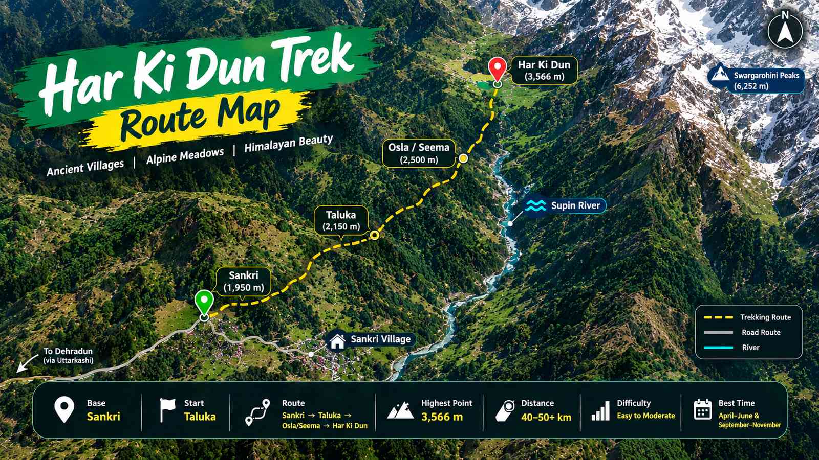
The Har Ki Dun Trek Route Map is not simply a line from Sankri to a destination. It is a gradual journey through some of Uttarakhand’s most distinctive landscapes—remote villages, dense forests, river valleys, open meadows and high Himalayan scenery.
Located in the Uttarkashi district, Har Ki Dun sits at approximately 3,566 metres. The traditional approach begins around Sankri and Taluka, then enters the Supin River valley before reaching settlements such as Osla and Seema and eventually the Har Ki Dun basin. Current route sources show variations in the exact trail and distance, so trekkers should treat published figures as route-dependent rather than one fixed measurement.
Har Ki Dun Trek Route Map at a Glance
| Route Feature | Details |
|---|---|
| Destination | Har Ki Dun Valley |
| District | Uttarkashi, Uttarakhand |
| Base Village | Sankri |
| Traditional Roadhead | Taluka |
| Main Valley Route | Taluka → Gangad/Osla/Seema → Har Ki Dun |
| Highest Point | Approx. 3,566 m |
| Main Watercourse | Supin River |
| Landscape | Forests, villages, river valleys & alpine meadows |
| Difficulty | Generally Easy to Moderate / Moderate |
| Approx. Distance | Roughly 40–50+ km depending on route |
The frequently quoted 47 km round-trip figure refers to a Taluka-based route in one current 2026 guide. Other route maps calculate distance differently, which is why you may see shorter or longer numbers online.
Understanding the Har Ki Dun Route
A simplified version of the route is:
Sankri → Taluka → Gangad → Osla/Seema → Kalkattiyadhar → Har Ki Dun
But this shouldn’t be interpreted as one rigid trail. Different trekking operators use slightly different campsites and approach points. For example, current route descriptions include Puani Ghaat, Boslo, Kalkattiyadhar and Seematra in different versions of the route.
This is one reason a good Har Ki Dun Trek Route Map is more useful than relying only on a distance figure.
1. Sankri: Where the Mountain Journey Begins
Sankri is the familiar gateway to the Har Ki Dun region.
The village sits at roughly 1,900 metres and acts as a base for several trekking routes in the area. From here, the landscape begins changing quickly—busy roads give way to forested mountain tracks and increasingly remote settlements.
For trekkers, Sankri is where the final preparations usually happen before entering the trail.
2. Taluka: The Transition from Road to Trail
Taluka is traditionally regarded as the main roadhead for the Har Ki Dun trek.
The route from Sankri to Taluka is an approach road, while the walking trail begins beyond this point. Current sources commonly describe the Sankri–Taluka approach as roughly 12 km, although road conditions and access can change.
Once you start walking, the character of the journey changes.
You enter forest terrain, encounter streams and bridges, and begin following the river valley deeper into the mountains.
3. The Supin River Becomes Your Natural Guide
One of the defining features of the Har Ki Dun route is the Supin River.
Rather than feeling like an isolated mountain path, sections of the trek have a strong connection with the river landscape. Forests rise around the valley while the river cuts through the terrain below.
Depending on the exact route, trekkers encounter bridges, streams, rocky sections and changing vegetation.
This combination of water + forest + mountain terrain gives the lower part of the Har Ki Dun trail its distinctive character.
4. Gangad, Osla & Seema: Where the Route Gets Cultural
Har Ki Dun is interesting because the trail isn’t only about wilderness.
The route passes through Himalayan settlements such as Gangad, Osla and Seema. These villages provide a glimpse into the traditional lifestyle of communities living in the upper Supin valley.
Osla, in particular, is known for its traditional wooden architecture and cultural heritage.
For travellers, this means the trek combines two experiences:
Himalayan wilderness + living mountain culture.
That combination is a major part of what makes the Har Ki Dun route different from a trek where the entire trail is simply forest and mountain.
5. From Forests to Open Mountain Country
As the route gains elevation, the scenery begins to open.
Dense woodland gradually gives way to broader slopes and high-altitude meadows. The trail becomes less enclosed, allowing the surrounding mountains to dominate the view.
This transition is particularly noticeable around the higher sections associated with Kalkattiyadhar and the approach toward Har Ki Dun. Current route descriptions place Kalkattiyadhar around the upper part of the trail before the valley opens out.
6. Har Ki Dun Valley: The Landscape Opens Up
Then comes the defining moment of the route—the arrival into the Har Ki Dun Valley.
At approximately 3,566 metres, the valley is surrounded by dramatic Himalayan terrain and is associated with views toward peaks including the Swargarohini group.
Instead of a conventional summit, Har Ki Dun offers something different: a broad mountain valley where the landscape itself becomes the destination.
The change from forested trail to open high-altitude terrain is one of the most memorable parts of the route.
Har Ki Dun Route: Landscape Changes
| Route Zone | Landscape |
|---|---|
| Sankri | Mountain village and forested surroundings |
| Taluka | Roadhead and beginning of walking trail |
| Lower Trail | Dense forest and river valley |
| Gangad / Osla / Seema | Traditional villages and cultivated slopes |
| Kalkattiyadhar Area | More open mountain terrain |
| Upper Har Ki Dun | Alpine meadows and high Himalayan scenery |
| Har Ki Dun Valley | Broad valley surrounded by major peaks |
How Long Is the Har Ki Dun Trek?
This is where many online articles become confusing.
You may find 34 km, 47 km, 50 km or even longer figures while researching the same trek.
That doesn’t necessarily mean one source is wrong.
The difference can come from:
- Where the walking distance begins
- Whether Sankri–Taluka road travel is included
- Different campsites
- Alternative trail sections
- Optional exploration routes
- Whether the calculation is one-way or round-trip
For example, one current 2026 route guide gives approximately 47 km from Taluka and back, while another route map describes a 34 km Sankri-to-Sankri trekking figure excluding driving.
A practical way to describe it:
The Har Ki Dun Trek covers roughly 40–50+ km depending on the selected route, roadhead and optional sections.
That wording is more useful for trekkers than pretending there is one universal distance.
Har Ki Dun Altitude Map
The altitude also changes gradually rather than jumping suddenly from lowland to high mountain terrain.
| Location | Approx. Elevation |
|---|---|
| Sankri | ~1,900 m |
| Taluka | ~1,900–2,200 m |
| Osla / Seema | ~2,560–2,600 m |
| Kalkattiyadhar | ~2,950 m |
| Har Ki Dun | ~3,566 m |
Exact elevations can differ slightly between route maps and individual trail points. Current published sources consistently place Har Ki Dun itself around 3,566 m.
What Will You See on the Har Ki Dun Route?
The route offers considerably more variety than the phrase “Himalayan trek” might suggest.
🌲 Forest Corridors
Lower sections pass through Himalayan forests with conifers and broadleaf species. Depending on the season, rhododendron blooms can add colour to the trail.
🏡 Traditional Villages
Osla and nearby settlements make the route feel inhabited rather than completely remote.
💧 River Landscapes
The Supin River and its tributaries are recurring features of the trail.
🌿 High-Altitude Meadows
The upper route becomes increasingly open, with broad grassy landscapes replacing dense forest.
🏔️ Himalayan Panorama
The higher valley provides views toward major Himalayan peaks, including the Swargarohini group.
Route Highlights You Should Mark on Your Map
| Map Point | Why It Matters |
|---|---|
| Sankri | Main base and preparation point |
| Taluka | Traditional trekking roadhead |
| Gangad | Important settlement on route variations |
| Osla | Cultural and architectural highlight |
| Seema | Major trail/camping area |
| Kalkattiyadhar | Higher open mountain section |
| Har Ki Dun | Main destination |
| Marinda Tal | Optional nearby high-altitude attraction on some routes |
When Is the Har Ki Dun Route Most Enjoyable?
There isn’t one perfect month for everyone.
Spring brings greenery and flowering vegetation, while post-monsoon months are known for clearer Himalayan visibility. Winter creates a completely different snow-covered landscape but requires greater preparation.
| Period | Typical Trail Character |
|---|---|
| April–June | Spring greenery, flowers and relatively comfortable conditions |
| July–August | Monsoon influence; wet and potentially difficult trails |
| September–November | Clearer mountain views and cooler conditions |
| Winter | Snowy landscape and significantly colder conditions |
Trail access can change because of weather, road conditions and local restrictions, so current conditions should always be checked before departure.
Is the Har Ki Dun Route Suitable for Beginners?
The standard Har Ki Dun route is commonly described as easy to moderate or moderate, but “beginner-friendly” doesn’t mean effortless.
The route still involves:
- Long mountain walks
- Uneven surfaces
- Gradual altitude gain
- Changing weather
- Remote sections
- Limited facilities away from villages
A person who regularly walks or exercises should prepare with longer walks, stair climbing and basic endurance training before attempting the trek.
Why a Route Map Matters More Than an Itinerary
An itinerary tells you when something happens.
A route map tells you where you are going and how the landscape connects.
For Har Ki Dun, the second question is particularly important because the trail combines road approaches, forest sections, villages, river valleys and high-altitude terrain.
A useful route map should therefore show:
Sankri → Taluka → major villages → upper trail → Har Ki Dun Valley
It should also distinguish road travel from trekking distance.
Har Ki Dun Trek Route Map – Quick Reference
| Question | Answer |
|---|---|
| Where is Har Ki Dun? | Uttarkashi district, Uttarakhand |
| Main base? | Sankri |
| Traditional roadhead? | Taluka |
| Highest point? | Approx. 3,566 m |
| Main river? | Supin |
| Important villages? | Gangad, Osla, Seema |
| Approx. walking distance? | Around 40–50+ km depending on route |
| Difficulty? | Easy to Moderate / Moderate |
| Main attraction? | Har Ki Dun Valley and Himalayan mountain scenery |
The Route Is the Experience
The biggest mistake is to think of Har Ki Dun as simply a trek to a valley.
The experience actually begins long before you reach the destination.
It starts with the mountain road into Sankri, continues through Taluka and the Supin valley, becomes more culturally interesting around Osla and Seema, opens into higher mountain terrain and finally reaches the wide landscape of Har Ki Dun.
That progression—from village roads to forests, from forests to river valleys, and from river valleys to high Himalayan meadows—is what makes the route worth exploring.
If you’re planning your journey with Dream Go Himalayas, use the route map to understand the terrain first, then plan your transport, equipment and trek dates around the current trail conditions.